


AERIAL INSPECTIONS
Precise inspections and data interpretation in 2D and 3D
Precise technical inspections and aerial monitoring
At AuditAir, we turn aerial survey data into information you can act on, beyond attractive images.
We combine RTK positioning, detailed aerial imagery and AI-assisted analysis to help you identify a problem, understand its extent and plan the next step – on roofs, façades, construction sites and industrial premises.
We deliver practical information for maintenance, technical management, defect claims, insurance claims and repair planning: photographic documentation, orthophotos, 3D models and online remote inspections.

Dronová kontrola striech pre presné meranie plôch, diagnostiku poškodení a získanie detailných záberov z ťažko dostupných miest. Kvalitná fotodokumentácia je však len prvý krok – následne vytvárame centimetrovo presné 3D modely využiteľné pre technické a inžinierske práce, projektovanie aj plánovanie opráv. Model je možné ďalej rozšíriť o interiérové skenovanie, vďaka čomu získate komplexný pohľad na objekt zvonka aj zvnútra.

Profilové ortofoto historickej kostolnej veže (120+ rokov) pre úvodné technické posúdenie stavu. Po dronovom zameraní a fotogrametrii pripravujeme presné 3D podklady a CAD výkresy pre projektovanie, plánovanie opráv a koordináciu realizačných prác.
Dronová kontrola striech pre presné meranie plôch, diagnostiku poškodení a získanie detailných záberov z ťažko dostupných miest. Kvalitná fotodokumentácia je však len prvý krok – následne vytvárame centimetrovo presné 3D modely využiteľné pre technické a inžinierske práce, projektovanie aj plánovanie opráv. Model je možné ďalej rozšíriť o interiérové skenovanie, vďaka čomu získate komplexný pohľad na objekt zvonka aj zvnútra.
Roofs and
facades
Quick building condition check – no scaffolding, no guesswork, with evidence
The roof and facade are among the most expensive parts of a building and are also the most difficult to inspect. Drone surveys give you an up-to-date and detailed picture of the condition without working at height, risk and inaccurate estimates from the street. It is ideal for maintenance, repair preparation, contractor inspection and wind/hail damage.
What you get:
Current status without assumptions: critical areas such as flashings, penetrations, attics, gutters, joints, cracks, loose elements
Precise location and scope: so that the repair is done purposefully, not "blindly"
Comparison over time: "before/after" repairs, regular checks and tracking of changes
Better team coordination: administrator, designer and investor see the same data – even remotely
Outputs (as needed):
detailed photo documentation with marked findings
orthophoto of roof / facade (like the current map, only much more detailed)
3D preview for quick orientation
basic measurements of areas and lengths for the repair plan
online tour for team and investors (e.g. Nira or equivalent)
Construction sites and real estate - monitoring
Regular drone flights over a construction site will give you an up-to-date, objective and comparable picture of what is really happening on the site. It is ideal for developers, construction supervisors, project managers and foreign investors - when you need to monitor progress without frequent trips and without "feel-good reports".
What you get:
Check progress over time: clear comparison week by week / month by month
Evidence: documentation for handovers, complaints, changes, disputes and invoicing
Fast decision-making: everyone is looking at the same data (construction manager, supervisor, investor)
Better coordination of subcontracts: visible slippages, collisions, access routes, material dumps
Outputs (as needed):
regular photo report from the same points (consistent comparison)
orthophoto progress map (current status as "construction map")
3D preview / digital twin for quick orientation and communication
simple tags and comments on findings
online tour for team and investors (e.g. Nira or equivalent)

Ortofoto progress mapa z dronu poskytuje presný, aktuálny pohľad na stav staveniska a postup zemných prác v konkrétnom termíne. Slúži ako spoľahlivý podklad pre kontrolu realizácie, porovnanie v čase, koordináciu profesií a dokumentáciu pre investora, stavebný dozor aj projektový tím.

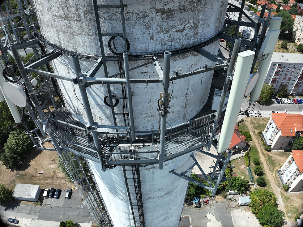
Detailná dronová inšpekcia plášťa a strešnej časti veže umožňuje bezpečne zdokumentovať poškodenia povrchov, koróziu, poruchy oplechovania a ďalšie rizikové miesta bez potreby lešenia. Výstupom je presná fotodokumentácia a podklady pre technické posúdenie, plánovanie opráv a rozpočet údržby.

Pravidelný dronový monitoring stavby prináša aktuálny a porovnateľný prehľad o postupe prác, kvalite realizácie a stave objektu. Z leteckých dát pripravujeme fotodokumentáciu, ortofoto a 3D podklady, ktoré pomáhajú developerom, stavebnému dozoru aj investorom pri kontrole, koordinácii a rozhodovaní.
Ortofoto progress mapa z dronu poskytuje presný, aktuálny pohľad na stav staveniska a postup zemných prác v konkrétnom termíne. Slúži ako spoľahlivý podklad pre kontrolu realizácie, porovnanie v čase, koordináciu profesií a dokumentáciu pre investora, stavebný dozor aj projektový tím.


Vizualizácia pozícií viac než 1 400 dronových snímok použitých na presné zameranie konštrukcie pre technickú inšpekciu. Tento spôsob zberu dát umožňuje detailne zdokumentovať prakticky každý povrch objektu a vytvoriť centimetrovo presný 3D model aj v miestach, ktoré sú bez lešenia alebo priameho prístupu ťažko kontrolovateľné.
Industrial areas – surfaces, roads, parking lots, drainage
Problems with roads and drainage within a site develop gradually and are often addressed only after causing damage, a complaint or downtime. A drone survey provides an overview of the whole site and helps make maintenance a planned process.
What you gain:
-
An at-a-glance overview for site maintenance: where surfaces are deteriorating and where hazards are developing for vehicles, equipment and people
-
A basis for repair planning and budgeting: divide the site into sections and prioritise repairs
-
A quick check of drainage routes: identify areas where water accumulates after rain or blockages are likely
-
Documented condition for contractors and tenants: before and after work, or when assessing a damage claim
Deliverables, as required:
-
Site maintenance map – an orthophoto showing sections and problem areas
-
Findings register with photographs, locations and brief risk or priority notes
-
Priority list: immediate action / next maintenance cycle / later
-
Measurement data for a bill of quantities: basic lengths, areas and sections
-
Online viewing for the team using NIRA or an equivalent platform
documentation for an insured event
After a storm, hail, wind, flooding or accident, it is crucial to have a clear and documented status as soon as possible: where the damage occurred, what is its extent and what is risky. Drone survey will allow you to safely inspect even inaccessible places (roofs, attics, facades, technological parts) and prepare documents so that they are usable for the insurance company and for the decision on repair.
What you get:
Quickly map the extent of damage: so as not to delay inspections and guesswork
Evidence documentation in the right context: what is damaged, where exactly and what it looked like on that day
Separation of critical risks: loose elements, places with a risk of leakage, dangerous parts for the movement of people
Basis for coordinating intervention: repair, security, temporary solution – everyone sees the same thing
Outputs (as needed):
incident report with photo evidence and a clear structure (object → zone → finding)
damage map (orthophoto with marked damaged zones)
timestamp + consistent documentation for the insurance company and internal audit
package of documents for the repair contractor (location, scope, spatial context)
sharing via online inspection (Nira or equivalent) for quick remote approvals

Interiérové skenovanie a presná fotodokumentácia priestoru po škode vytvárajú spoľahlivý podklad pre poistné plnenie, technické posúdenie a plánovanie opráv. Výstupy zachytávajú stav objektu v konkrétnom čase, rozsah poškodenia aj priestorový kontext, čo zjednodušuje komunikáciu s poisťovňou, dodávateľmi a realizačným tímom.
Interiérové skenovanie a presná fotodokumentácia priestoru po škode vytvárajú spoľahlivý podklad pre poistné plnenie, technické posúdenie a plánovanie opráv. Výstupy zachytávajú stav objektu v konkrétnom čase, rozsah poškodenia aj priestorový kontext, čo zjednodušuje komunikáciu s poisťovňou, dodávateľmi a realizačným tímom.
Why AuditAir?
We bring fast and safe drone monitoring for roofs, facades, construction sites and industrial areas - with outputs that can be used immediately in practice. Instead of estimates, you get a clear picture of the condition of the object, precise localization of problems and documentation for maintenance, repairs, complaints and insurance claims.
We deliver clear outputs as needed: photo documentation, orthophoto, 3D preview and online inspection so that the administrator, designer, investor and insurance company can quickly reach an agreement - even remotely.