


MAPPING AND CALCULATIONS
data interpretation in 2D and 3D
At AuditAir, we turn mapping into a clear picture of reality.
This is not another output to be put in a drawer, but rather data that can be realistically used in decision-making.
We combine RTK accuracy, photogrammetry, and 3D modeling so you can instantly see what is where, how much of it is, and how it changes over time – on the building site, in the grounds, on the property, and in the landscape.


Orthophoto maps of the territory
An orthophotomap is the fastest and most understandable way to get an accurate and up-to-date view of an area – to scale, with measurement and clear spatial context. For many clients, it is the first moment they stop relying on old maps, estimates or “feel of the terrain” and start making decisions based on reality.
That is why it is the most frequently ordered mapping service. Orthophoto maps are used as a common basis for discussion - between owners, designers, the municipality, suppliers and the public. Everyone is looking at the same picture.
At AuditAir, we deliver orthophotos so that they are immediately usable – in the office, in the field, and for further planning. If a project later requires formal geodetic verification, we can seamlessly follow up through partner surveyors, without repeating data collection.
clear and up-to-date basis for decision-making
Accurate measurements of areas and distances without assumptions
ideal for municipalities, industry, development and land management
excellent for comparing changes over time (before/after intervention)
Outputs: georeferenced high-resolution orthophoto map, GIS layers, exports for CAD and documents prepared for further professional use.
Mapping of buildings
and areas
Overview without scaffolding and without entering into operation
With large buildings and extensive areas, the problem is often not finding out that something needs to be addressed, but how to get an accurate overview safely, quickly and without disrupting normal operations. Aerial mapping allows you to capture the entire building or area at once - without scaffolding, without production shutdowns and without risk to employees.
This service is particularly popular with facility managers, manufacturing companies, logistics centers, and public institutions that regularly deal with repairs, renovations, or investment planning. Instead of partial inspections, it creates a unified and objective picture of the status that can be returned to at any time.
Mapping is suitable not only before intervention, but also as an initial state ("as-is") before design, supplier selection or internal decision-making. The outputs significantly simplify communication between technicians, management and external companies - everyone works with the same data.
roofs, halls, paved areas and communications in one overview
quick orientation in large or complex areas
"as-is" documentation as a neutral and archival basis
possibility of regular mapping and monitoring of changes over time
support for planning maintenance, repairs and investment interventions
Aerial mapping is also suitable for repeated condition checks - for example after storms, reconstructions or technological changes. The client thus obtains not only a one-time overview, but also a long-term picture of the development of the site.
Outputs: orthophoto of the area, 3D view, precise measurements, sections and a technical report tailored to the client's specific needs.


Area and volume calculations
When you need to know how much – and have it substantiated
Area and volume calculations are among the most common reasons why mapping is ordered. In practice, it is not just about how the area looks, but especially how much material, space or capacity is involved. Clients need accurate and verifiable numbers that can be relied on when planning work, checking progress and evaluating costs.
Drone mapping allows you to obtain this data quickly, safely and repeatably – without entering dangerous or hard-to-reach places and without subjective estimation. All calculations are based on current data, which significantly reduces the risk of errors and ambiguities.
A big advantage is the ability to compare the status over time. When mapping repeatedly, it is clear exactly what has changed, how much material has been added or removed, and how the work is progressing. Such an overview simplifies control and communication between investors, suppliers, and management.
calculations of volumes of excavations, embankments, landfills and dumps
measuring land areas, plains and paved areas
comparison of volumes over time (work progress, changes)
understandable and repeatable data for decision-making and control
objective data usable for budgets, records and reporting
The outputs are prepared in a way that can be easily shared, archived and further processed – either internally or in collaboration with external experts. The client thus receives not only one-time figures, but also a reliable tool for long-term monitoring of developments.
Outputs: volume calculations, spreadsheets, map layers and sections ready for further use.
Materials for designers and surveyors
Data that saves time and simplifies preparation
AuditAir provides map data as a practical input for experts – designers, architects and surveyors. The aim is not to replace their work, but to significantly simplify the preparatory phase of projects and reduce the number of returns to the field. This way, the project can start with an up-to-date and clear picture of the territory from the very first step.
In practice, this means that experts work with the real state of the territory, not with outdated data or estimates. Mapping data allows for a faster understanding of the context, identification of constraints, and better preparation of the proposal before detailed design.
The outputs are structured to fit seamlessly into common CAD and GIS workflows and can be used immediately in design and planning tools. If a project requires formal geodetic accuracy, verification or stamp, we work with surveyors so that the client does not have to coordinate multiple suppliers and the entire process is smooth.
compatibility with CAD and GIS tools used in practice
precise georeferencing and clearly structured data layers
suitable for territorial studies, project preparation and alternative solutions
documents that shorten preparation time and reduce the risk of errors
seamless connection to geodetic services through partner experts
Such documents serve as a common basis for all parties involved – designers, investors and public administration. They facilitate communication, reduce ambiguities and help make decisions before costly interventions in the field begin.
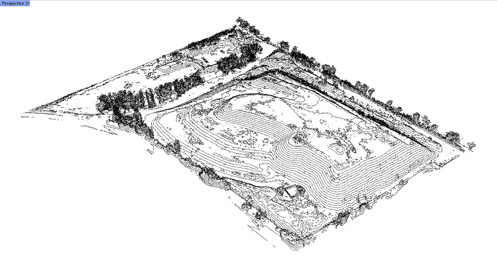
Outputs: orthophoto, 3D data, point clouds, sections and layers ready for professional processing and further project steps.


Why AuditAir?
Because mapping is not just about "flying it with a drone". It is about accuracy, the right methodology and an output that can be used in practice. We deliver georeferenced orthophoto maps, 3D data and measurable calculations so that they fit into the CAD/GIS workflow and so that you can rely on them for control, budgets and decision-making. And most importantly: we do it repeatably - so that you can compare the status today and in a month, not just have a pretty picture.
© 2025 by AudtAir sro